
Satellite remote sensing has evolved from experimental agricultural research into operational crop monitoring infrastructure, with UK farmers increasingly utilising multi-spectral imagery to detect emerging stress conditions weeks before visual symptoms become apparent at field level. The technology centres on measuring vegetation health through spectral reflectance patterns, particularly the Normalized Difference Vegetation Index (NDVI), which quantifies photosynthetic activity and biomass density with remarkable sensitivity to physiological changes occurring within plant tissue.
This early warning capability transforms crop management from reactive problem-solving into proactive intervention, enabling agronomists to address nutrient deficiencies, disease outbreaks, pest infestations, and moisture stress during critical windows when corrective actions deliver maximum benefit. The economic implications prove substantial when yield losses prevented through timely intervention are balanced against minimal technology costs, with free satellite data platforms now providing capabilities that previously required expensive aerial surveys or ground-based scouting programmes.
The following analysis examines the science underlying NDVI measurements, operational satellite platforms serving UK agriculture, practical interpretation techniques, integration with ground-truthing protocols, and documented performance advantages from operations that have embedded remote sensing into standard crop monitoring workflows.
Understanding NDVI and Vegetation Spectral Signatures
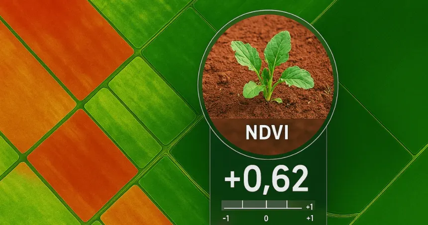
The Normalized Difference Vegetation Index exploits fundamental differences in how healthy vegetation interacts with visible red and near-infrared radiation. Chlorophyll molecules within leaf tissue strongly absorb red light (630-680nm wavelength) for photosynthesis whilst cellular structures reflect near-infrared radiation (750-900nm), creating a distinctive spectral signature that varies predictably with plant health, biomass density, and photosynthetic capacity.
NDVI calculations compare these two spectral bands using the formula (NIR – Red) / (NIR + Red), producing values between -1 and +1 where healthy, actively growing vegetation typically registers 0.6-0.9, stressed or sparse vegetation falls within 0.3-0.6, bare soil ranges from 0.1-0.2, and water bodies return negative values. This normalisation process cancels variations in solar illumination, viewing angle, and atmospheric conditions, delivering consistent measurements across different acquisition dates and environmental conditions.
The index responds to multiple physiological factors affecting crop condition. Nutrient deficiencies, particularly nitrogen stress, reduce chlorophyll concentration and therefore decrease red light absorption, lowering NDVI values before visible yellowing occurs. Water stress causes leaf wilting and reduced turgor pressure, altering cellular structure and near-infrared reflectance characteristics whilst photosynthetic impairment affects red band absorption. Disease infections and pest damage disrupt both chlorophyll function and cellular integrity, creating detectable NDVI reductions that appear days to weeks before symptoms become obvious through conventional scouting.
The two-week early detection advantage cited by many UK operations reflects the lag between initial physiological disruption detectable through spectral analysis and the development of visual symptoms recognisable during field inspections. This timing advantage proves most significant for conditions where early intervention substantially improves treatment efficacy, including fungal diseases responsive to protectant fungicides, insect infestations manageable before population explosions, and nutrient deficiencies correctable through foliar applications or targeted fertiliser placement.
Satellite Platforms Serving UK Agriculture
Sentinel-2 represents the dominant free data source for agricultural remote sensing, operated by the European Space Agency with twin satellites providing 5-day revisit frequency over the UK and 10-metre spatial resolution in the red and near-infrared bands critical for NDVI calculation. The open-access policy eliminates direct data costs whilst the Copernicus programme’s long-term commitment provides operational reliability suitable for integration into standard farm management protocols.
The 10-metre resolution delivers adequate detail for field-scale monitoring, with individual pixels representing 100 square metres that resolve within-field variability on most UK arable operations. However, this resolution proves marginal for smaller fields common in certain regions and insufficient for horticultural operations requiring plant-level or row-level detail. The 5-day nominal revisit frequency increases effectively through the two-satellite constellation but remains constrained by cloud cover, with UK weather patterns frequently limiting usable image acquisition to one quality capture per 10-15 days during growing seasons.
Planet Labs operates a commercial constellation delivering 3-metre resolution imagery with daily revisit capability, addressing both the spatial and temporal limitations of free alternatives. The enhanced resolution reveals detailed within-field patterns whilst daily acquisition ensures cloud-free imagery availability despite frequent UK overcast conditions. Subscription costs vary by area monitored and image frequency required, typically ranging £800-£2,500 annually for farm-scale operations, with pricing structured to encourage larger coverage areas and longer subscription terms.
The resolution improvement from 10-metre to 3-metre pixels proves most valuable in situations requiring precise stress location identification, including detecting disease infection centres, identifying equipment malfunction patterns (blocked sprayer nozzles, fertiliser spreader irregularities), and monitoring small trial plots or varied cropping systems. The finer detail supports targeted intervention strategies that direct scouting efforts or precision applications to specific field zones rather than broad-scale treatments.
Commercial providers including Airbus, Maxar, and various agricultural technology platforms offer additional satellite imagery options with specifications ranging from moderate-resolution operational monitoring through very-high-resolution (50cm-1m) tasked acquisitions supporting specific investigation needs. These services typically integrate with broader precision agriculture platforms, bundling imagery with interpretation algorithms, agronomic decision support, and farm management system integration.
Operational Image Interpretation Techniques
Baseline establishment forms the foundation of effective satellite crop monitoring, with early-season imagery captured during uniform crop establishment providing reference conditions for detecting subsequent variation. Operations typically acquire baseline images 4-6 weeks after crop emergence when vegetation coverage reaches 40-60% and spatial patterns reflect field characteristics rather than transient establishment variability. This reference enables relative comparisons throughout the season, with departures from expected NDVI trajectories triggering investigation rather than absolute threshold violations.
Time-series analysis tracks NDVI evolution across multiple acquisition dates, revealing temporal patterns that distinguish different stress types. Gradual NDVI decline over 2-4 weeks suggests progressive nutrient limitation or developing moisture stress, whilst rapid drops between successive images indicate acute problems including disease outbreaks, pest infestations, or severe weather damage. Localised NDVI reductions appearing suddenly suggest equipment malfunction or application errors, whilst expanding patches indicate spreading disease or pest populations requiring immediate attention.
Within-field spatial patterns provide diagnostic value beyond simple NDVI magnitudes. Stress appearing in topographic low spots suggests waterlogging or drainage issues, whilst hilltop or exposed areas showing reduced vigour indicate moisture or wind stress. Linear patterns often indicate application equipment problems or residual effects from previous field operations, whilst irregular patches suggest disease infection centres or localised pest concentrations. These spatial signatures guide both immediate investigation priorities and longer-term management zone delineation for variable rate applications.
Comparative analysis between fields or farm blocks identifies unusual conditions by highlighting areas performing significantly worse than locations expected to show similar growth patterns. This technique proves particularly valuable on large operations where simultaneous monitoring of multiple fields challenges conventional scouting capacity, with comparative imagery immediately directing attention to fields showing anomalous performance.
Integration with weather data, growth models, and historical yield records contextualises NDVI measurements within broader agronomic frameworks. Expected NDVI values vary with crop type, growth stage, variety, and recent weather conditions, with interpretation algorithms increasingly incorporating these factors to distinguish actionable stress signals from normal variation. Sophisticated platforms compare current NDVI values against crop-specific growth curves, flagging deviations exceeding expected ranges whilst filtering routine fluctuations.
Ground-Truthing Protocols and Validation
Systematic field verification transforms satellite observations into actionable intelligence, with effective protocols defining when, where, and how ground-based assessments validate remote sensing detections. Operations typically prioritise investigation of areas showing NDVI reductions exceeding 15-20% relative to field norms or baseline conditions, focusing limited scouting resources on locations where satellite data indicates problems whilst accepting that some borderline signals represent normal variation requiring no intervention.
Targeted scouting routes follow graduated sampling strategies, examining severely affected areas first to characterise primary stress factors, then investigating transition zones where NDVI values shift from stressed to healthy vegetation, and finally verifying apparently healthy reference areas to confirm stress absence rather than uniform but subtle problems. This approach efficiently diagnoses stress causes whilst validating that satellite-detected patterns reflect actual field conditions rather than image artefacts or processing errors.
Diagnostic protocols address specific stress categories suggested by NDVI patterns and temporal characteristics. Suspected disease issues require detailed canopy inspection for infection symptoms, spore presence, and characteristic lesion patterns, with samples collected for laboratory confirmation when field diagnosis proves uncertain. Nutrient deficiency investigation includes tissue sampling for laboratory analysis, visual leaf symptom assessment, and examination of whether patterns correlate with known soil variations. Pest problems require population counts, damage assessment, and lifecycle stage determination that informs treatment timing decisions.
Documentation systems record relationships between satellite signals and verified field conditions, building institutional knowledge that improves interpretation accuracy over multiple seasons. Effective operations photograph ground-truthed locations, record GPS coordinates, document observed conditions, and link these field observations to corresponding NDVI values and image dates. This accumulated experience enables increasingly confident differentiation between stress types based on spectral signatures alone, reducing ground-truthing requirements as operators recognise familiar patterns.
Calibration activities periodically validate NDVI measurement accuracy against field-measured variables including crop height, biomass samples, leaf area index measurements, and chlorophyll meter readings. These checks ensure interpretation algorithms remain appropriately tuned whilst identifying situations where NDVI fails to detect known stress conditions, refining understanding of technology limitations and informing decisions about when alternative monitoring approaches prove necessary.
Economic Returns from Early Stress Detection
Yield protection represents the primary economic benefit, with early intervention preventing losses that would otherwise occur if stress conditions progressed undetected until conventional scouting identified problems. Representative financial models demonstrate the economic logic underpinning satellite monitoring adoption across UK arable operations.
A hypothetical scenario demonstrates typical returns. Consider a 400-hectare winter wheat operation experiencing a Septoria outbreak affecting 60 hectares (15% of the farm). Satellite detection occurring 14 days before visual symptoms appear enables protectant fungicide application costing approximately £45 per hectare (product plus application). Without early detection, the disease establishes before treatment, reducing fungicide efficacy and resulting in estimated yield losses of 0.8 tonnes per hectare across the affected area.
At £200 per tonne wheat price, prevented losses total £9,600 (60 hectares × 0.8 tonnes × £200) against early intervention costs of £2,700 (60 hectares × £45), generating net benefit of £6,900 from this single incident. Annual satellite monitoring costs for a 400-hectare operation range £0-£1,200 depending on whether free Sentinel-2 data suffices or commercial Planet imagery proves necessary, with either investment justified by single-event returns of this magnitude.
Input efficiency improvements provide additional returns through precision application targeting, with satellite-detected within-field variation supporting variable rate strategies that concentrate inputs where response potential justifies costs. Nitrogen fertiliser applications guided by NDVI-based prescription maps typically achieve 5-12% input savings whilst maintaining or improving yields through better spatial matching of supply to crop demand, generating annual returns of £8-£18 per hectare on intensive arable operations.
Risk management benefits accrue through earlier awareness of developing problems, providing additional time for informed decision-making rather than rushed responses to crisis situations. This temporal buffer proves particularly valuable when intervention options require coordination with contractors, custom applicators, or specialist service providers who may have limited availability during peak demand periods.
Labour efficiency gains emerge as satellite monitoring concentrates field scouting on areas warranting detailed investigation rather than routine coverage of all fields regardless of condition. Large operations report 30-50% reductions in scouting time requirements after implementing satellite-based monitoring systems, with quality of observations improving through focus on genuinely problematic areas rather than perfunctory walks through uniformly healthy crops.
Integration with Precision Agriculture Systems
Modern farm management platforms increasingly incorporate satellite imagery as standard functionality, with NDVI maps displayed alongside yield data, soil analysis results, and application records within unified interfaces that support integrated decision-making. This consolidation eliminates the standalone monitoring approach that previously characterised satellite imagery use, embedding remote sensing within broader precision agriculture workflows where information from multiple sources informs management actions.
Variable rate application prescription maps derive directly from NDVI data in many systems, with algorithms translating vegetation indices into fertiliser rates, plant growth regulator doses, or desiccant application prescriptions calibrated through ground-truthed relationships between NDVI values and optimal input rates. These automated prescription generation capabilities reduce the agronomic expertise required for precision agriculture adoption, though validation against field conditions remains essential to prevent inappropriate applications based on misinterpreted imagery.
Yield prediction models incorporate NDVI measurements alongside weather data and crop growth algorithms, providing mid-season yield forecasts that inform marketing decisions, harvest logistics planning, and storage requirements. Prediction accuracy improves substantially through integration of actual vegetation performance data rather than relying solely on modelled crop development, with typical mid-season prediction errors falling to 8-12% of final yields compared to 15-25% errors from weather-driven models alone.
Performance benchmarking utilises NDVI trends to evaluate treatment efficacy, variety performance, and management practice outcomes through comparative analysis between field areas, treatments, or seasons. This analytical capability transforms satellite data from a monitoring tool into an evaluation platform that quantifies agronomic decisions’ impacts and guides continuous improvement efforts.
Practical Implementation Considerations
Data platform selection determines operational workflows, cost structures, and integration capabilities, with options ranging from direct access to raw satellite imagery requiring in-house processing expertise through turnkey agricultural platforms that deliver interpreted results and management recommendations. Operations with strong technical capabilities and specific analytical requirements may prefer direct data access, whilst most UK farms benefit from integrated agricultural platforms that eliminate processing complexity and provide agronomic context alongside raw imagery.
Subscription models vary significantly, with some platforms charging per-hectare annual fees (typically £2-£6 per hectare depending on service level), others bundling satellite monitoring within comprehensive precision agriculture packages, and several offering freemium approaches providing basic functionality at no cost with premium features available through paid upgrades. Total cost of ownership includes not only direct platform fees but also time invested in image interpretation, ground-truthing activities, and integration with existing farm management processes.
Connectivity requirements generally prove modest, with satellite platforms designed for rural internet access constraints and offering mobile applications that operate effectively on cellular networks. However, high-resolution image downloads and detailed analytical work benefit from better connectivity, with some operations experiencing frustration when attempting sophisticated analysis via marginal rural broadband connections.
Training investment ensures effective technology utilisation, with most agricultural satellite platforms requiring 2-4 hours of initial instruction to understand interface navigation, interpretation fundamentals, and integration with existing workflows. Ongoing learning occurs through practical application, with interpretation confidence building over multiple seasons as users accumulate experience linking satellite observations to field-verified conditions.
Satellite remote sensing has matured into reliable, accessible technology that delivers measurable operational advantages for UK crop production. The two-week early detection benefit represents a consistent pattern across multiple stress types and farming systems, with this timing advantage translating into tangible yield protection and input efficiency gains that justify technology adoption across an expanding range of operations seeking quantitative crop monitoring capabilities.


